Description of the 30-day and 90-day diagrams
Daily mean air temperature
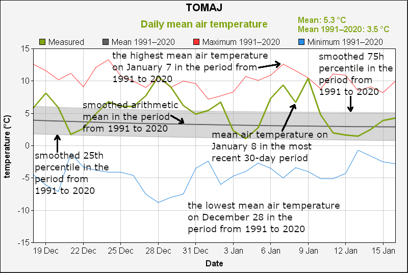
Daily mean air temperature is calculated as the sum of one-quarter of the temperature at 7 a.m., one-quarter of the temperature at 2 p.m., and half of the temperature at 9 p.m. (time being solar or winter, depending on the station type).
Statistics for the period 1991–2020 are also plotted: the highest and lowest values of a particular calendar day, smoothed arithmetic mean (dark gray line), and smoothed range between the 25th and 75th percentiles (gray band). Smoothed values are calculated using the LOESS method.
Missing data is marked by pink columns.
Two statistics are presented in the upper right corner of a diagram: mean value of the most recent time period and the corresponding mean of the period from 1991 to 2020. Only the days having both values available are included in the calculation of the means.
Daily lowest air temperature
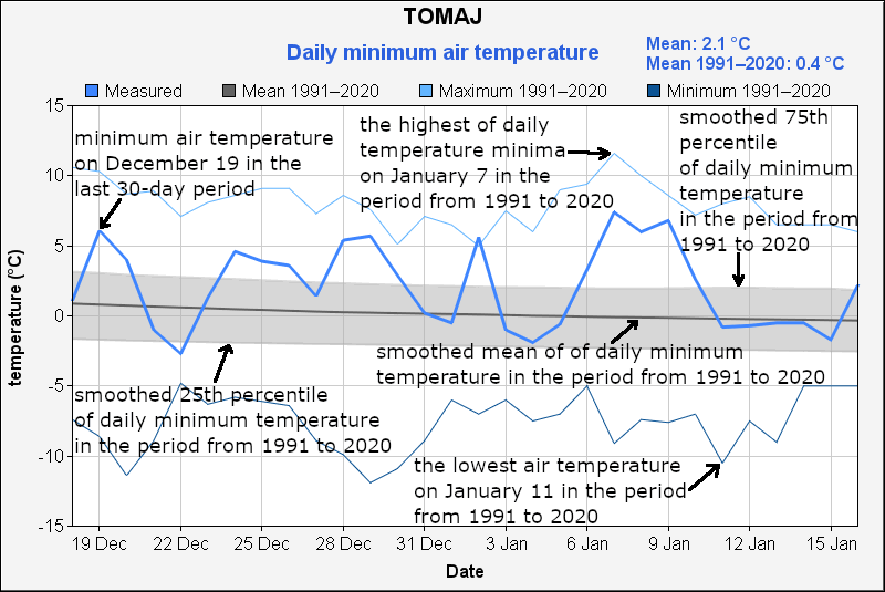
Daily lowest temperature is the lowest temperature value within the 24-hour period, which starts at 9 p.m. (solar or winter time) the previous day and ends at 9 p.m. of the denoted day.
Statistics for the period 1991–2020 are also plotted: the highest and lowest values of a particular calendar day, smoothed arithmetic mean (dark gray line), and smoothed range between the 25th and 75th percentiles (gray band). Smoothed values are calculated using the LOESS method.
Missing data is marked by pink columns.
Two statistics are presented in the upper right corner of a diagram: mean value of the most recent time period and the corresponding mean of the period from 1991 to 2020. Only the days having both values available are included in the calculation of the means.
Daily highest air temperature
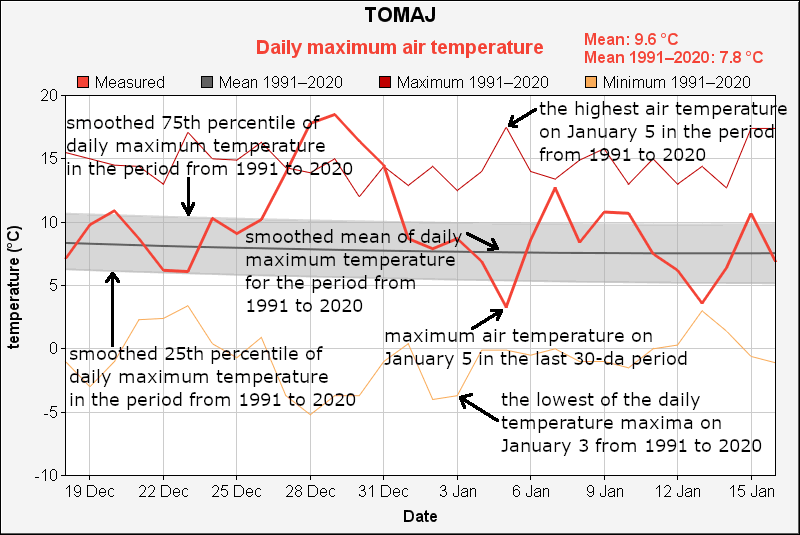
Daily highest temperature is the highest temperature value within the 24-hour period, which starts at 9 p.m. (solar or winter time) the previous day and ends at 9 p.m. of the denoted day.
Statistics for the period 1991–2020 are also plotted: the highest and lowest values of a particular calendar day, smoothed arithmetic mean (dark gray line), and smoothed range between the 25th and 75th percentiles (gray band). Smoothed values are calculated using the LOESS method.
Missing data is marked by pink columns.
Two statistics are presented in the upper right corner of a diagram: mean value of the most recent time period and the corresponding mean of the period from 1991 to 2020. Only the days having both values available are included in the calculation of the means.
All temperature variables

Daily mean air temperature is calculated as the sum of one-quarter of the temperature at 7 a.m., one-quarter of the temperature at 2 p.m., and half of the temperature at 9 p.m. (time being solar or winter, depending on the station type). Daily lowest and highest temperatures are the extremes of the 24-hour period, which starts at 9 p.m. (solar or winter time) the previous day and ends at 9 p.m. of the denoted day.
Daily precipitation sum
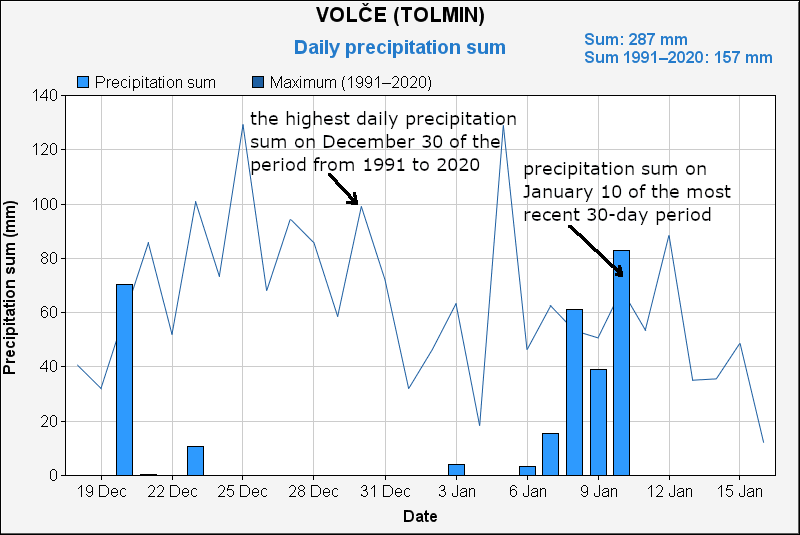
The daily precipitation sum represents all the precipitation that falls between 7 a.m. (winter time) of the previous day and 7 a.m. of the denoted day. The precipitation sum is expressed in millimetres or litres per square metre (both units can be used interchangeably).
In addition to the "current" values, the highest calendar day values for the period 1991–2020 are plotted.
Missing data is marked by pink columns.
Two statistics are presented in the upper right corner of a diagram: precipitation sum of the most recent time period and the corresponding mean sum of the period from 1991 to 2020. Only the days having both values available are included in the calculation of the means.
Snow depth
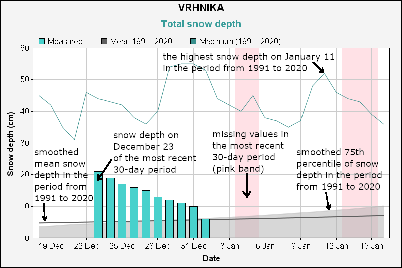
Snow depth represents the total depth of snow cover on the grass at 7 a.m. (winter time) and is expressed in centimetres.
Statistics for the period 1991–2020 are also plotted: the highest value of a particular calendar day, smoothed arithmetic mean (dark gray line), and smoothed range between the 25th and 75th percentiles (gray band). Smoothed values are calculated using the LOESS method.
Missing data is marked by pink columns.
Daily bright sunshine duration
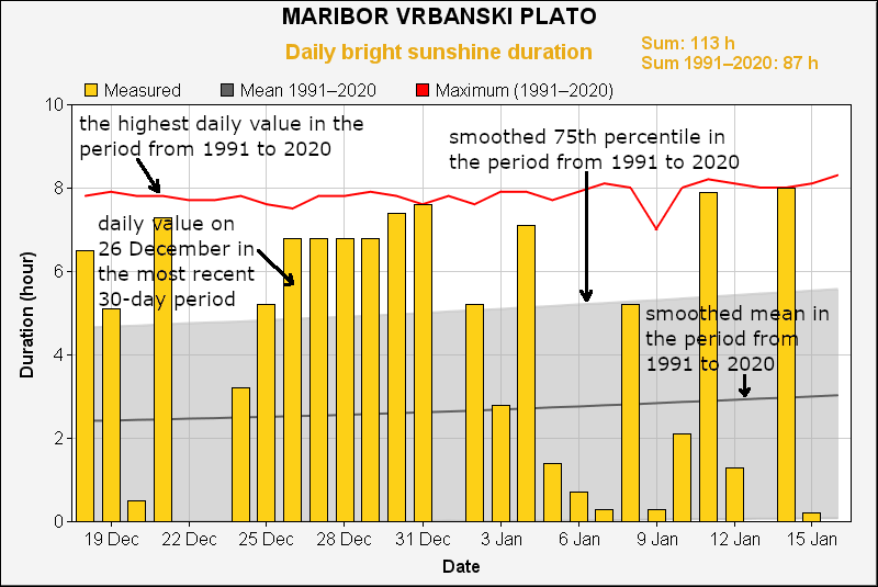
Daily bright sunshine duration is the total time in a day when the solar irradiance perpendicular to a surface exceeds a limit, typically 120 watts per square metre (for manual heliographs, the limit heavily depends on the weather—air temperature, wind speed, etc.). The sunshine duration approximately corresponds to the duration of "sunny weather".
Statistics for the period 1991–2020 are also plotted: the highest value of a particular calendar day, smoothed arithmetic mean (dark gray line), and smoothed range between the 25th and 75th percentiles (gray band). Smoothed values are calculated using the LOESS method.
Missing data is marked by pink columns.
Two statistics are presented in the upper right corner of a diagram: the sunshine duration of the most recent time period and the corresponding mean sunshine duration of the period from 1991 to 2020. Only the days having both values available are included in the calculation of the means.
Data preparation for the diagrams of the series
Time series are calculated using homogenised and interpolated daily data of various meteorological variables from 1950 to 2020, and for bright sunshine duration from 1960 to 2022. Later data are quality-controlled measurements, with most missing values substituted by interpolated values. Both manual and automatic measurements contribute to the homogenized and interpolated time series, while the later data are primarily from automatic measurements.
It should be noted that for some measuring sites, the spatial interpolation of temperature is less reliable and the data shown is less precise due to the site's microclimate compared to neighboring sites. For example, a site might be in a frost hollow, a shadow-dominated valley, a sunny slope, or a wind-exposed location. Since we have homogenized the time series only with respect to the monthly means, some daily values could significantly deviate from the true value (which wasn't measured). We estimate that the deviation from the true values is below 1°C for most stations on the majority of days in the historical period. However, in extreme cases, the deviation could surpass 5°C. Generally speaking, the deviations are higher for minimum than for maximum and mean temperatures, although this rule doesn't apply to every station and each month of the year.
The quality of precipitation sum and snow depth data is mostly affected by strong winds, making the data for wind-exposed sites (especially on mountaintops such as Slavnik, Uršlja Gora, Kanin, and Kredarica) less reliable, particularly during snowfall. Bright sunshine duration measurements are heavily influenced by nearby obstacles (e.g., trees) or terrain features at a few sites. Thus, the data from such sites may not reflect the general sunshine characteristics of a larger area around the site. Measuring sites like Zelenica, Iskrba (Štalcerji), and Kredarica, among others, are examples of such sites.
The methodology of homogenisation and interpolation of the temperature and precipitation time series is presented in an article published in the journal Vetrnica (of the Slovenian Meteorological Society), issue 15/23, pp. 54-80: https://www.meteo-drustvo.si/glasilo/arhiv-vetrnic . https://www.meteo-drustvo.si/glasilo/arhiv-vetrnic .
Diagrams for the last 30 days
Diagrams for the last 90 days
|

